Facebook creates an AI-based map of Africa to help with crisis relief
Imagine a world in which relief agencies respond more quickly and effectively to disasters like Cyclone Idai because they have detailed mapping tools telling them where to deliver assistance. That’s exactly what Facebook plans to do in its new creation of an artificial intelligence-based map of Africa to help with crisis relief.
Facebook partnered with Columbia University’s Center for International Earth Science Information Network to ensure that they get the best available administrative data for all countries involved.
https://scontent.fnbo5-1.fna.fbcdn.net/v/t39.2365-6/57070581_2165982993486555_479643088415883264_n.gif?_nc_cat=109&_nc_ht=scontent.fnbo5-1.fna&oh=e5179adebcf3432311edebc0bcd14b9a&oe=5D3BCF4B
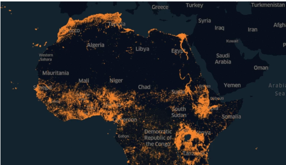
Facebook used advanced computer vision and machine learning to combine satellite imagery from DigitalGlobe (an American commercial vendor of space imagery and geospatial content) with public census data and other sources to create detailed population density maps in Africa.
“Using a mixture of machine learning techniques, high-resolution satellite imagery, and population data, we mapped hundreds of millions of structures distributed across vast areas and then used that to extrapolate the local population density,” Facebook said in a blog post.
The new map of Africa will show exactly where the continent’s 1.3 billion people live, down to the meter.
High-resolution satellite imagery already exists for much of the world. However, prior to Facebook’s mapping project, it would have required countless hours for volunteers to comb through millions of square miles of pictures to identify which contained a tiny town or remote village.

Facebook says that when it is completed, humanitarian agencies will be able to determine how populations are distributed even in remote areas, so that health care workers can better reach households and relief workers can better distribute aid.
“Africa alone has 1.2 billion people across nearly 16 million square miles; its largest census tract is 150,000 square miles with 55,000 people. If researchers knew where the houses or other buildings were located in these tracts, they could create extremely accurate density maps by allocating the population proportionally to each one,” Facebook said.
The new venture is inspired by Facebook’s previous success. It released the first set of maps two years ago and this improved how nonprofits do their work, how researchers learn and how policies are developed.
For example, in Malawi, the Red Cross and the Missing Maps program, in partnership with the Malawi Ministry of Health, used Facebook maps to inform a measles and rubella campaign.
“By showing that 97% of land space was uninhabited, the Red Cross was able to deploy 3,000 trained local volunteers to specific areas in need,” Facebook said.
Tyler Radford, executive director of the Humanitarian OpenStreetMap Team says that the maps from Facebook will ensure that, “we focus our volunteers’ time and resources on the places they’re most needed, improving the efficacy of our programs.”
This is however not the first time Facebook is creating AI maps, in 2016 it created maps for 22 nations.


